Note from the editor of Next: The City Council will vote on how best to proceed in planning for the conversion of Santa Monica Airport into a park at tonight’s City Council meeting. Todd Flora will have a report later this week at Santa Monica Next. The below article first appeared at The Healthy City Local.- DN
“The City is at an important point in the process of understanding how this project should serve Santa Monica and the wider region for several hundred years.” From Page 4, Agenda Item 7-A Staff Report for the July 8, 2025 meeting of the Santa Monica City Council.
That is my favorite sentence of the staff report for Tuesday’s night’s City Council meeting where the council will take the next steps to convert the Santa Monica Airport into a park. The sentence puts in context both the importance of the project and the time to get it done.
I have problems with the Staff Report (see below), but there are other good parts.
One of them is the PowerPoint that HR&A, the City’s financial advisors, prepared to give an overview of possible financing sources for the park. Although this report is preliminary, in part because HR&A did not have a program with specific costs to consider, I was pleased to learn of possible sources I knew nothing about. These include two forms of tax-increment financing, “Enhanced Infrastructure Financing Districts” and “Climate Resilience Districts,” that City Council could establish at the appropriate time.
Another good thing in the Staff Report is the summary of 69 “letters of interest” (LOIs) that staff received from entities and persons with ideas for how they could participate in development and/or operation of the park. Many of the ideas are unlikely to happen, but some have real potential.
One proposal, for instance, comes from California State Parks to join with Santa Monica in building and/or operating the park for “habitat restoration, cultural programming, and public recreation aligned with the state’s climate and equity goals.” We don’t have details, but one assumes that State Parks could bring in state money. Keep in mind that Santa Monica already cooperates with State Parks in the operation of the beach, which is formally a state park known as “Santa Monica State Beach”.
Other proposals come from sports groups that could help build and operate sports facilities.
Another LOI came from a major contractor firm, the Griffith Company, which proposes to create an on-site processing yard to recycle the concrete and asphalt that will result from removing runway and tie-down areas. Griffith says this will reduce environmental impacts as well as produce income for the City during the removal process. Removing the tarmac could be a major cost; if Griffith can cover it by recycling the materials, that’s in effect another financial source for the park.
Some of the LOI proposals are more long-term and would require more public process. For instance, New Roads School proposes to swap their current site on Olympic Boulevard, a site better located for housing than the airport, for land at the airport. New Roads would build a new campus there, and share cultural and recreational facilities with the City, much as the City now shares facilities with public schools. This proposal would probably need a vote to amend Measure LC and, as I said, more public process. It would need to wait, but it’s the kind of project that could utilize already built-on land at the airport, land that would be harder to turn into park.
The summary of LOIs is a plus, but it ends with a throwaway paragraph: “At this time, there are no further steps associating with the LOIs. This list is provided to City Council for consideration on how the Preferred Scenario of Phase 3b should move forward and if any of these ideas are intriguing enough to instruct staff to continue exploring any of these ideas in the future.”
What a letdown. Maybe Sasaki and staff could have given City Council a heads up on which proposals might be helpful in building and operating the park? Do they expect the council members, who are not professional park designers, to go through these 69 proposals one by one? To find out which are “intriguing enough”?
Which brings me unhappily to the rest of the report. I could glean some other nice bits, but this is a blog, and sorry, I am going to exercise blogger’s privilege and focus on the negative.
I will try to explain what is disappointing in the report, and what reflects a disappointing process, by focusing on the third of the three scenarios that Sasaki developed to frame the future development of the site. Scenario 3 is the one that the Sasaki called, “Growing Park, Growing Community,” and it envisions “a complete neighborhood model with expanded housing and commercial development to support a regional park.”
Repeatedly the planners have told us that they developed the three scenarios only as schematics, to give ideas for what would go into a preferred alternative. Yet repeatedly in the Staff Report the scenarios, particularly Scenario 3, are lovingly described as complete projects; e.g., “Scenario 3 envisions a bold new urban district, a ‘complete neighborhood’ wrapped around a signature civic park.” (I’m confused: “regional” or “civic?” Later we learn the park would likely be “privatized.”)
Here is the plan for Scenario 3:
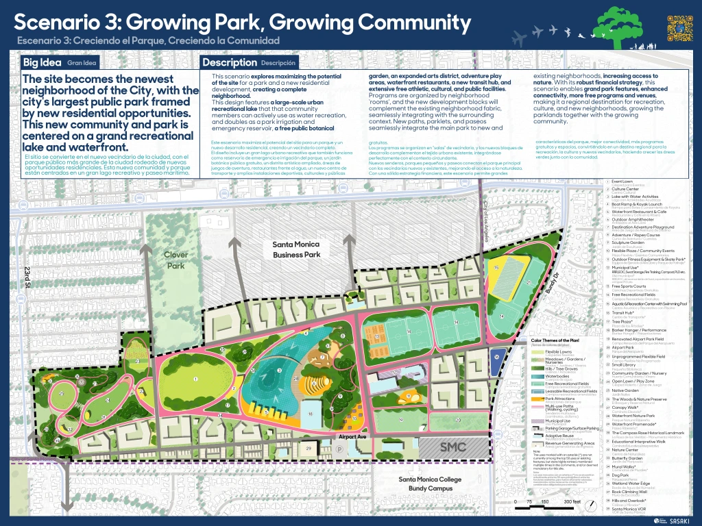
I can’t help but wonder: is this plan an homage to modernist superblocks from the 50s or to New Urbanist new towns of the 90s?
By the way, who asked Sasaki to design a neighborhood? I was at the January 28 City Council hearing and I heard the council ask for three park scenarios including one with “some housing.” Based on the survey data, certainly the public didn’t ask for a new neighborhood. Instead the planners gave us two scenarios with a lot of housing and other development and not much park: Scenario 2 has only 102 acres of park and Scenario 3 has only 114 acres.
We already have a city. What we need is a park.
Sasaki wasted a lot of time, energy and money on these two scenarios. Why do I say “wasted”? Because they are never going to happen. Why? Because of topography: the airport site is barely accessible. It is a huge, isolated superblock, next to another superblock (Penmar Golf Course), and cannot be connected to the grid or to significant public transit.
From the south, there is no access to the airport site.
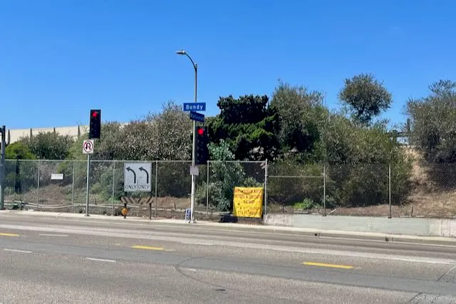
From the east there is access only from one entrance on Bundy, and on Bundy a large grade separation makes further connections unlikely or expensive, as this photo of the intersection with National shows.
From the north it is possible to extend streets to connect the airport with Ocean Park Boulevard, but if there were to be significant development on the site, those roads would need to be little highways cutting up the park.
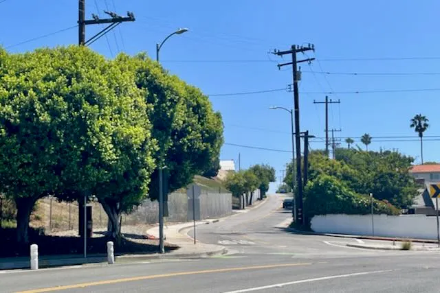
On the west, the airport site is only reachable up a steep incline on a two-lane road, Airport Avenue, that rises up from the scariest intersection in Santa Monica, the one where 23rd Street becomes Walgrove Avenue in L.A. The roads cannot be widened there without extraordinary measures.
The Staff Report says that if the City moved forward with Scenario 3, “circulation systems for pedestrian, vehicular, and park connectivity [would be] fully restructured.”
What does this mean? In true modernist tradition, do the planners want to build an overpass to connect Airport Avenue to Dewey Street and then turn Dewey into a four lane road to connect the airport site to Lincoln Boulevard? (Something like this happened before in Santa Monica, when the Ocean Park neighborhood was ripped in half by a widened Ocean Park Boulevard, including an overpass at 4th Street, to connect Lincoln to the urban renewal project that was supposed to result in a Miami Beach West.) I know this sounds ridiculous, but the whole plan is ridiculous.
Okay, you are saying, but the park will have these access issues, too. But park traffic will not only be less, but also concentrated in off-peak hours. Housing isolated from transit is going to produce traffic just like all other commuting traffic.
Neither Scenario 2 or 3 could ever work for other reasons, too, some of which are even mentioned in the staff report. For instance, how is market-rate housing going to fund the park if it also has to subsidize affordable housing and build the infrastructure that the airport doesn’t have?
And then there is this bombshell admission in the Staff Report, buried at the end of analysis of Scenario 3: “The scenario raises questions about long-term park identity and whether it remains a civic anchor or becomes a central green within a privatized development pattern.” (Emphasis added.) Honestly, I read this sentence and my stomach turned. How could such a “scenario” make its way into a report on building a park in Santa Monica?
I hope that City Council takes charge of this project and tells the planners to stop wasting time and money on visionary, top-down “big plans” that make no sense. Yes, City Council asked for a plan that was financially feasible. But the easiest way to plan a financially feasible park is to start with a modest plan. (See my previous column for recent examples where cities did that.) The problem is that planners don’t go to planning school to learn how to make little plans that evolve over time.
I also object to conclusory language from the planners that a park cannot be financed, because “the City has not yet identified sufficient financing.” Of course it hasn’t yet identified sufficient financing: it hasn’t yet started to look for it. And it can’t start looking for financing until it has a plan that will not cost immense sums for infrastructure and be dependent on a political campaign to get voter approval. Meanwhile the planners act as if their very shaky ideas for financing new neighborhoods are real, notwithstanding that they identify legal problems from Measure LC to the Surplus Land Act and financial problems like infrastructure costs.
As stated in the staff report, “the key question before City Council is whether the Preferred Scenario should include any uses that could or would require future voter approval, pursuant to Measure LC.” The answer should be an emphatic no. If plans for the park depend in any way on a public vote, then there will be no real plan for the park coming out of this (expensive) process. Everything will be contingent and dependent on politics.
Having said that, I don’t believe it would be a mistake to study housing as an alternative in the EIR, or in a separate economic or transportation analysis, so long as it can be done conceptually. I’m sure that there are folks out there who disagree with my analysis above about why the airport site is not a good one for development; I’m open to seeing what experts say. But not if it would mean spending significant time or energy, including public involvement, this fall on developing a hypothetical housing plan.
However, if housing is to be studied, the Staff Report contemplates “additional outreach related to height, type, unit mix, etc.” that would be “illustrated through a comprehensive set of materials, including site diagrams, cross-sections, 3D model views, precedent imagery, and perspective renderings, to clearly convey design feature and technical considerations.”
Please, no! No!
The City Council must not let Sasaki spend time and money developing plans for a modernist/New Urbanist fantasy neighborhood. If that happens, planning for the housing alternative will dominate the public outreach process this fall, alienating the public from the park planning process. Never has Santa Monica ever developed “specific plans” like this on the fly, as adjuncts to another planning process. Specific plans always come after general plans.
If there is going to be a housing alternative in the EIR, base it conceptually on some number of units located at some place on the map. See what comes up.
Thanks for reading.