

The following is a republication of Councilmember Dan Hall’s newsletter. It is reprinted with permission. Subscribe to get it sent straight to your inbox, here!
Adopted in 2016, Santa Monica’s Vision Zero set an ambitious goal: zero fatal and severe-injury traffic crashes by 2026. That deadline has now passed and we have failed to meet our goal. In the past five years, 21 lives have been lost due to traffic violence on our streets; 20 of the 21 have been pedestrians or bicyclists. Knowing this is unacceptable, at our February 10, 2026 meeting, Council approved a motion spearheaded by Mayor Pro Tempore Jesse Zwick and co-signed by myself and Mayor Caroline Torosis that made clear that Vision Zero’s deadline is not a failure to move on from but rather a moment calling for reinvestment, recommitment, and transformation of how the City designs, operates, and enforces its streets.
A Shift in Thinking at City Hall: the Safe System Approach
In response to this direction, City Staff is implementing a change in how we think about street safety. The shift centers on a science-backed methodology called the Safe System Approach. Rather than placing primary responsibility on individual drivers, cyclists, and pedestrians to make perfect choices, the Safe System Approach treats traffic safety as a shared responsibility across seven interconnected elements: Safe Speeds, Safe Roads, Safe Road Users, Safe Vehicles, Post-Crash Care, Safe Land Use, and Safe and Viable Transit. This represents a fundamental reorientation from the Five Es framework (Education, Encouragement, Engineering, Enforcement, Evaluation) that dominated traffic safety work for decades.
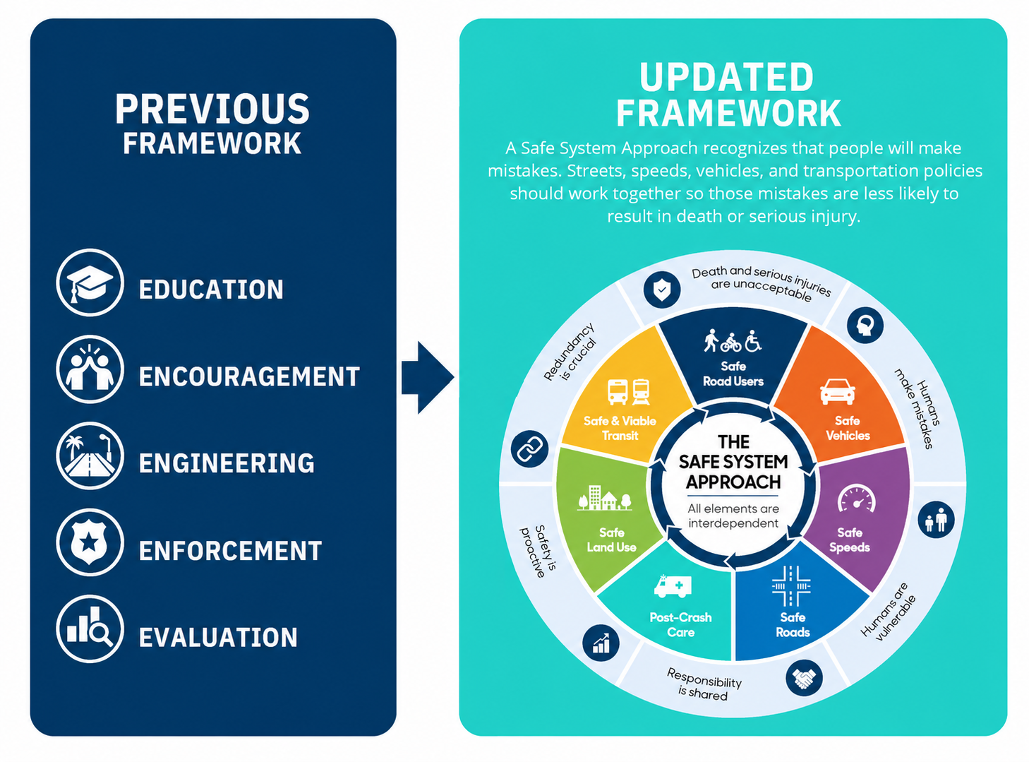
Why does this matter? Under the Five Es, a pedestrian struck at 40 miles per hour was often blamed for not “paying attention.” Under the Safe System Approach, the responsibility shifts: Why was a street designed to permit 40-mile-per-hour traffic through a pedestrian-dense area? Why did the road geometry invite speeding? What post-crash resources were available? These questions acknowledge that humans make mistakes… and that streets should be designed to account for those mistakes to minimize tragedy.
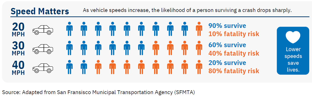
- Safe Speeds: Are posted speed limits and actual street design aligned with the consequences of crashes? At 20 miles per hour, a pedestrian has a roughly 90 percent survival rate. At 40 miles per hour, survival drops to 20 percent.
- Safe Roads: Physical design matters. Lane widths, curb radii, sight lines, protected bike lanes, bulb-outs, curb cuts, and traffic signals all communicate messages to drivers and protect vulnerable users.
- Safe Road Users: Education and awareness matter—but only after the system is designed safely. Road users are expected to occasionally fail; the system should minimize death and serious injury.
- Safe Vehicles: Technology saves lives. While municipal government cannot regulate vehicle manufacturing, it can advocate for adoption of safety technologies and consider their role in Vision Zero, which is something we do in our biannual legislative platform.
- Post-Crash Care: When crashes occur, emergency response and trauma care are critical. Survival rates depend on those critical minutes.
- Safe Land Use: Neighborhoods designed to promote walking, transit, and cycling reduce crash exposure by making these modes safer and more appealing.
- Safe and Viable Transit: Reliable, accessible public transportation offers a safe alternative to private vehicles.
Santa Monica’s Crash and Serious Injury Data Demand Action
Between 2021 and 2025, Santa Monica recorded 214 fatal and severe-injury crashes. Twenty-one people died; 20 of those individuals were pedestrians or cyclists. These data illuminate which streets are unsafe and for whom.
When the data is mapped, crash patterns emerge. Certain corridors, especially Ocean Avenue, Nielson Way, Main Sreet, and Lincoln Boulevard, and intersections near schools and transit hubs show repeated severe crashes. Some intersections are collision sites year after year. Others, despite high traffic volumes or illegal patterns of speeding (looking at you San Vicente drivers… slow down!), have less crashes.
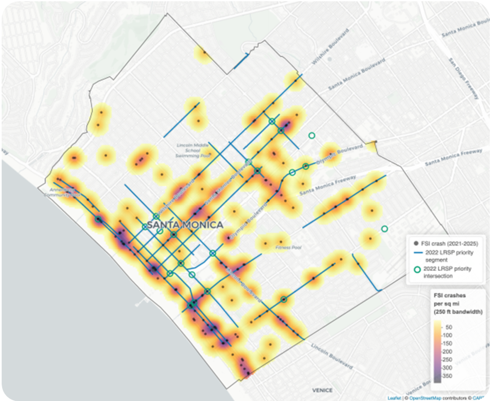
This distinction is critical: A high-traffic street may have many crashes but few severe injuries (often due to design features that naturally slow traffic). A lower-traffic street might have fewer crashes but a higher proportion of severe outcomes. Understanding both patterns—the high-risk corridors where collisions cluster and the high-injury corridors where crashes turn fatal or severe—is essential to targeting resources where they will save lives.
The Local Roadway Safety Plan: A Proactive Methodology
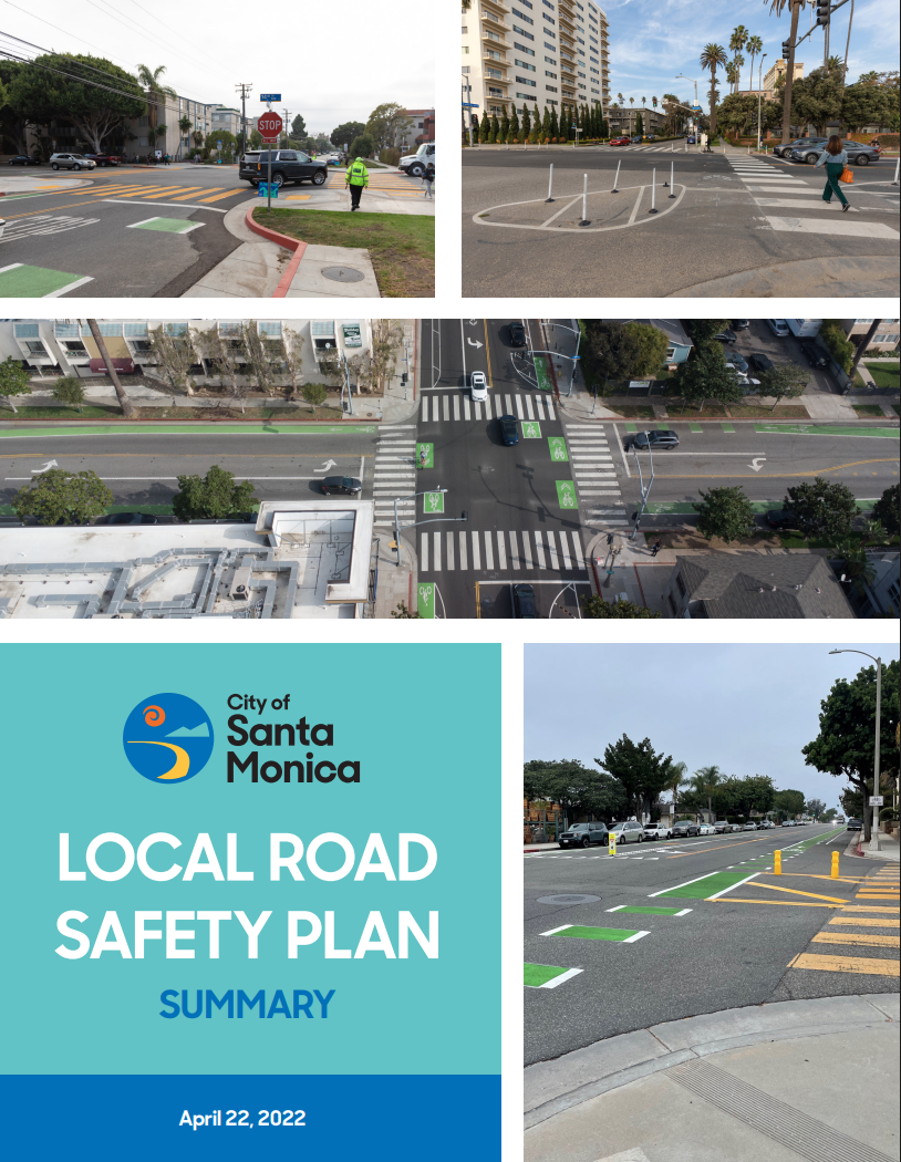
In September 2026, the City’s Public Works Department presented a framework to Council for identifying and addressing dangerous streets and intersections as a comprehensive update to the Local Roadway Safety Plan (LRSP). This methodology shifts the City from a reactive, complaint-driven approach to a proactive, data-driven one.
How the LRSP Works
Rather than waiting for residents to call in reports of hazardous conditions, submissions via 3-1-1 (please continue to do this!), or reacting after a crash occurs, the LRSP begins with an analysis of every street. The City identifies its High-Risk Network (streets where crashes cluster, regardless of severity) and its High-Injury Network (streets where crashes result in fatalities or serious injuries). These two maps do not always overlap.
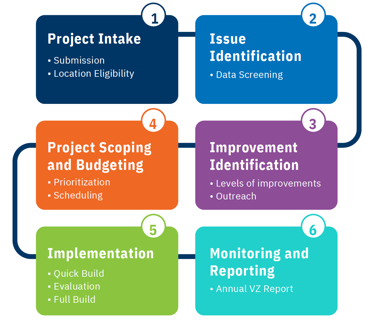
The LRSP uses this data to prioritize projects. A three-year cycle allows the City to analyze crashes, evaluate potential interventions, design improvements, and measure results. This creates a feedback loop: implement a project, track outcomes, adjust, and continue improving.
LRSP Projects and Implementation Timeline
The LRSP process has identified nine priority projects now in planning or under construction. These include corridor improvements on identified high-risk streets, intersection redesigns to reduce turning conflicts, and targeted speed management interventions. Each project is selected based on crash history, community impact, and technical feasibility.
Nine Street Safety Projects in Progress
Over the past six months, Santa Monica has begun implementing a series of near-term roadway-safety actions. These nine projects represent the first wave of work delivered through the Local Roadway Safety Plan and the quick-build capacity established through organizational consolidation.
Speed Management and Traffic Control
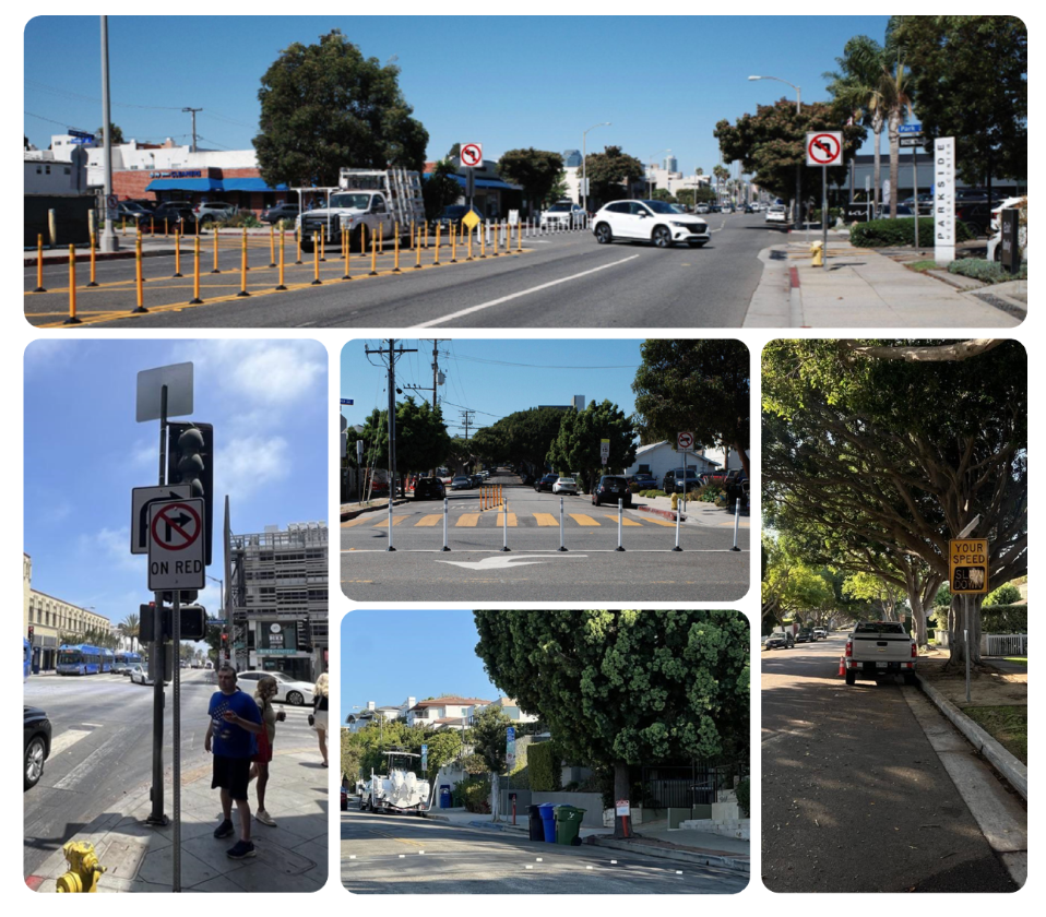
- Chelsea Avenue and Santa Monica Boulevard left-turn improvement: Quick-build treatment to manage left-turn conflicts and improve pedestrian crossing safety at McKinley Elementary School. (Deployed in time for the school year!)
- Berkeley Street speed humps: Vertical deflection to reduce operating speeds through physical street design. (Under construction)
- Neilson Way speed tables: Vertical deflection sized for higher-volume roadway context, with monitoring of transit and emergency operations. (In design)
- Speed feedback signs at Yale Street and Marine Street: Driver feedback signage to reinforce target speeds on residential corridors. (Deployed)
Intersection Safety and Signal Operations
- Stop-sign evaluations: Evaluation of approximately 30 intersections citywide for potential stop-sign installation against adopted criteria to reduce conflict severity. (Under evaluation)
- No-right-turn-on-red signage: Turn restrictions at selected intersections to reduce vehicle-pedestrian conflicts during crossing phases. (Deployed at various locations, concentrated in Downtown)
- Pedestrian recall installations: Signal operations changes so pedestrian phases are served automatically without push-button actuation. (Deployed at various locations)
Curb Loading and Zone Management
- Second and Fourth Street curb transition: Conversion of existing 15-minute parking spaces to designated loading and passenger drop-off zones as an interim step while Smart Curb Management procurement and enabling ordinances are completed. (In process of deployment)
Community Initiated Programs
- Neighborhood diverter pilot program: Resident-initiated diversion treatments. (Framework outlined in Neighborhood Traffic Calming Program; implementation underway)
Neighborhood Traffic Calming Program: Street Safety Starts with Residents
Community members know their streets better than any third party consultant. A parent who walks their child to school daily, a resident who has lived on a block for 30 years, a delivery driver who navigates the same intersections daily—these individuals see patterns that data alone cannot capture. The Neighborhood Traffic Calming Program (website is under construction, check back in the coming weeks for updates!) will formalize this knowledge by creating a structured process for residents to elevate safety issues and request street improvements.
Empowering Community Action
Residents will submit requests through a standardized form. The request will be evaluated against objective criteria: crash history, traffic volume, land use (schools, parks, senior facilities nearby), and equity considerations. Requests are then prioritized, designed, and implemented. This creates accountability: residents will not be ignored or told “we’ll think about it” as often happened in the past. They receive clear feedback on whether their request fits the criteria and, if approved, a timeline for implementation.
Early Results and Community Engagement
The program recognizes that traffic safety works better when the City works with a neighborhood to identify problem streets, intersections, and behaviors. A street redesign that ignores resident input often fails because it does not account for how people actually use the space. By building local voices into the process, the City improves both the quality of designs and community buy-in.
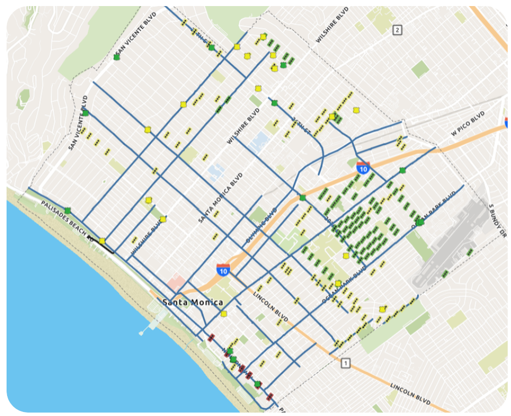
An example of a project that can be requested are speeding countermeasures. Below is a map of completed and currently requested countermeasures that will be added to over time via the new toolkit process.
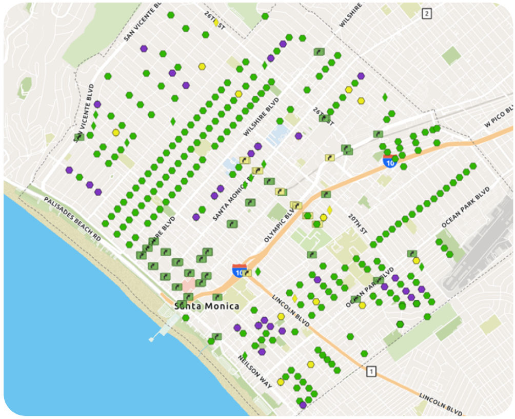
Another example is right of way treatments. Below is a map of completed and currently requested countermeasures that will be added to over time.
Organizational Changes as an Accelerant
Mobility Division Now Sits Within Public Works Department
In early 2026, Santa Monica consolidated its Mobility Division into the Department of Public Works. This was a strategic move to accelerate the path from identifying a dangerous street to fixing it.
Previously, a street safety issue would move between multiple City departments: Mobility, Public Works, and Planning. Each handoff created delays. Now, all functions for streetscape improvements sit within a single department. A crash analyst, a street designer, a construction manager, and a traffic engineer can sit in the same room and move from problem identification to solution design to implementation in weeks instead of months or years. This acceleration is essential to Vision Zero; streets that are unsafe today need to be fixed immediately before more lives are lost.
Automated Traffic Enforcement System: Data-Driven Compliance
Speed and signal compliance are foundational to safe streets. Yet many drivers exceed posted speed limits and run red lights without consequence. Automated Traffic Enforcement System (ATES) technology extends the City’s capacity to enforce these critical safety rules. Council gave final approval to a pilot program authorized under a new state law at our September 8 meeting, which will involve two priority intersections. The program will start by issuing warnings to vehicle owners who violate red lights for a limited period of time before moving into citations.
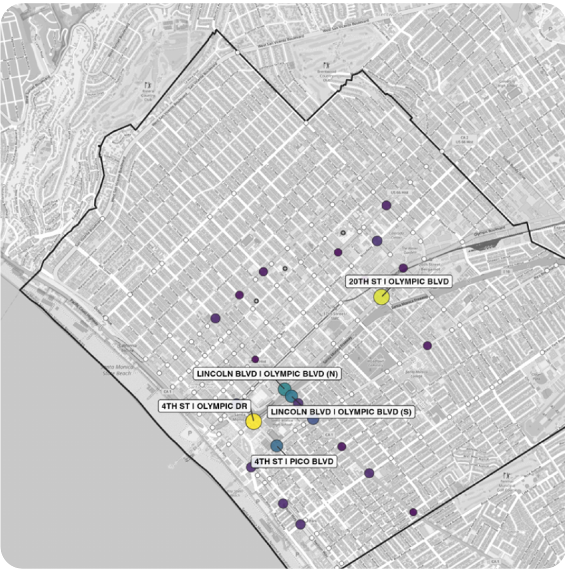
Strategic deployment will be key. Cameras will be installed at intersections with documented red-light violations and crash histories. Over time, ATES data will help answer critical questions: Are drivers complying more? Are crashes decreasing? Does the system need adjustment? Should we scale automated enforcement?
Note that the ATES data does not connect with Police data and is administered entirely separately as required under state law.
Greenways and Safe Transit Networks
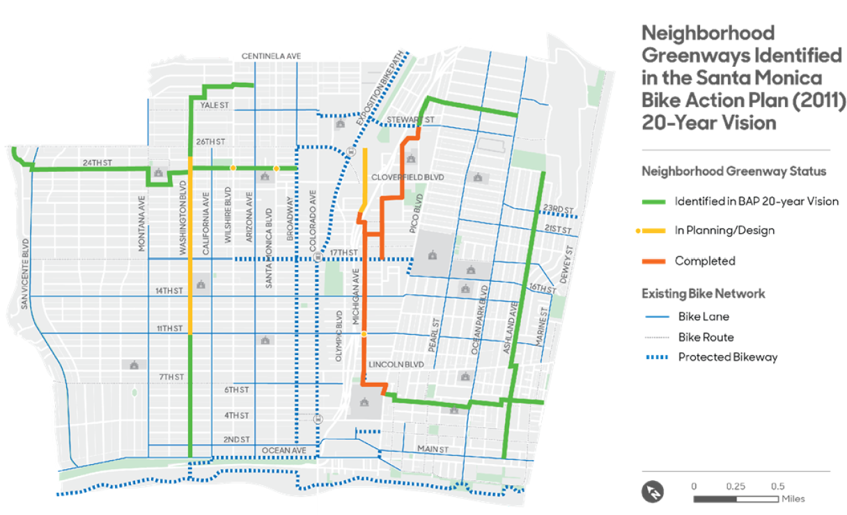
A street is safer when it is designed for multiple users: pedestrians, cyclists, people on transit, and vehicles. Santa Monica is expanding its greenway network—connected routes designed for walking and cycling—and prioritizing safe routes to schools and transit hubs. As we consider major real estate negotiations, updating our LRSP, and working with our schools community, the greenways plan is staying forefront in Council’s considerations.
Why, you ask? Because these greenway improvements serve Vision Zero in two ways. First, they provide safe alternatives to driving, reducing crash exposure. Second, they encourage slower speeds and more attentive driving on shared streets. A neighborhood where families walk and cyclists are visible is typically one where drivers drive more carefully. Oh, and let me say it one more time… SLOW DOWN! THERE ARE KIDS HERE!
The Way Forward
The Next 12 Months
Our work has already begun. Over the next year, you will see visible changes on Santa Monica’s streets. The nine LRSP-identified projects are moving into design and construction—some visible as new lane markings and curb extensions, others as repaved intersections with safer crossing patterns. Public Works will launch the Neighborhood Traffic Calming Program, and residents will be able submit their problem streets for evaluation.
At the same time, ATES data will be collected and analyzed. That information will feed directly back into the LRSP cycle: if a particular intersection continues to show dangerous patterns, it becomes a candidate for design intervention and increased enforcement.
Behind the scenes, our Public Works and Mobility teams are meeting with schools, transit agencies, community organizations, and neighbors. The goal here is simple: make sure that every street improvement we make serves the people who depend on it most: the child walking to school, the senior who takes the bus, and the cyclist commuting to work. We have given very clear direction to our Public Works and Mobility leadership that pedestrian and bicyclist safety is our number one priority, not vehicle speed, not vehicle throughput, and not vehicle access.
Measuring Success
Vision Zero success is measured in fatalities and severe-injury crashes. The City will continue to track these numbers publicly and report progress regularly. We will also track whether improvements are distributed across neighborhoods or concentrated in certain areas, ensuring that street safety advances equitably.
The metrics are straightforward: Are fatal crashes declining? Are severe-injury crashes declining? Are crashes happening less frequently in the neighborhoods where they were most concentrated? These numbers will tell us whether the updated Safe System Approach is working and where adjustments are needed.
Long-Term Vision: LRSP Evolution and Traffic Calming Expansion
The initial nine LRSP projects are the beginning of this reinvestment and recommitment to Vision Zero. The LRSP operates on a three-year cycle: analyze crashes, prioritize improvements, design and implement, measure results, and repeat. As the first cycle completes, new data will identify the next generation of projects. This creates a continuous feedback loop where each improvement informs the next.
The Neighborhood Traffic Calming Program is also designed to scale. As the intake and evaluation process proves its effectiveness, the City will expand the program with deeper outreach into neighborhoods and will process more requests. Residents will see faster timelines from request to implementation as the consolidated Public Works department streamlines the design-to-construction path.
Over the next three to five years, it is our goal that this systematic approach—combining data-driven LRSP projects with community-initiated Toolkit requests, supported by enforcement and organizational coordination—will create a measurable shift in Santa Monica’s traffic safety.
Thanks for being part of this recommitment to Vision Zero and reimagining how we can make our streets safer for everyone.
